There has been a lot of hullaballoo (and more hullaballoo) in the past week about a proposal by Utah’s senator Mike Lee and the Senate Energy and Natural Resources Committee to sell off federal BLM and USFS land to raise money to balance the Big Beautiful Bill, and to ostensibly make land available for affordable housing around growing cities in the West. The Wilderness Society quickly put out a very professional interactive map showing hundreds of millions of acres of public land under imminent threat. I applaud TWS for successfully creating a public panic (a tactic at which environmentalist groups are very adept), I share in their opposition to the proposal, and it sounds like the effort is leading Senator Lee to be more precise in the language of the bill.
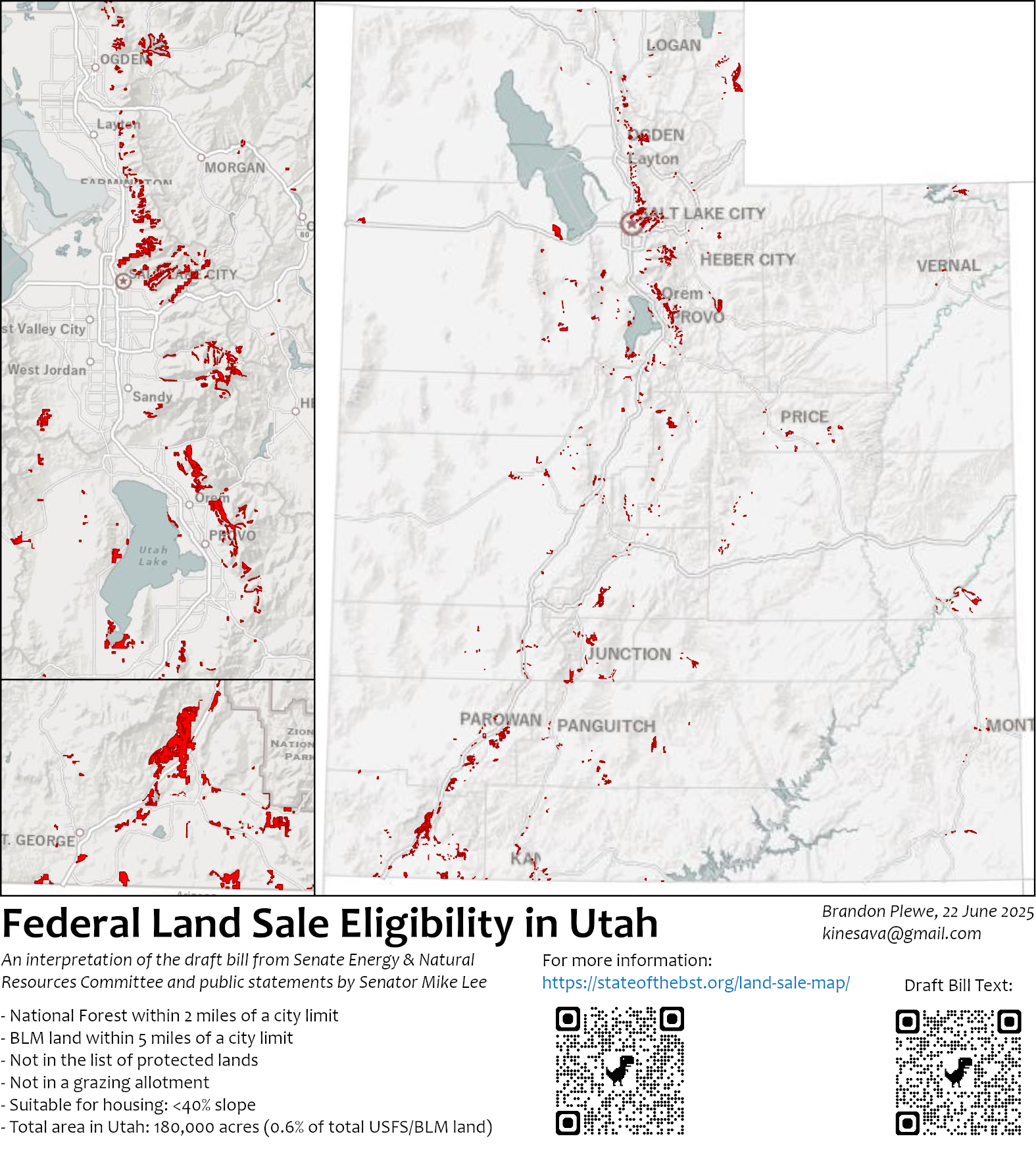
However, their map is extremely inaccurate, and I believe that a reasoned support or opposition should be based on fact. So I thought I would take a stab at it, at least for Utah (sorry other states, but Utah’s GIS data just makes this a lot easier, and I frankly care more about the lands I know). This map reflects the criteria as best as this non-lawyer mind could interpret the text, in addition to recent statements by Senator Lee promising to add a proximity-to-cities limit. So here were the criteria I used:
- BLM or USFS Land
- Not in the given list of protected areas (NP, NM, NCA, NRA, Wilderness, etc.)
- Not in a grazing allotment. This was the biggest difference from the TWS map (90% of the BLM & USFS land in Utah has grazing leases), not sure why they ignored it. One caveat, I used grazing allotments (potential leases), not currently active leases, which I couldn’t find. However, given the number of cows I see out on the trail, I think most of them are active.
- I did not exclude current mineral (esp. oil & gas) leases, I couldn’t find that data quickly.
- BLM land within 5 miles of a municipality, and USFS land within 2 miles of a municipality. This is not in any public text, just what Senator Lee has said publicly, so I’m not sure exactly how this will be written. Some of Utah’s city limits extend for miles beyond the land that is currently developed; I used city limits.
- Suitable for housing. This is a tough one, because there is a lot of room for interpretation. I used terrain less than 40% slope, which is a rather high limit; most cities would refuse anything over 30%. I probably should have added something about being adjacent to existing infrastructure, which is in the text, but also open to interpretation.
I’m not claiming that this map is perfect; it’s my interpretation of the information at hand. If there is a particular tract that you believe is in danger of being privatized, I strongly encourage you to research whether it meets the criteria, especially the grazing and mineral leases. If you can improve my interpretations and/or data, I would love to hear it.
First the good news. As you can see, this map is much less scary than the TWS map at first glance. If that map is the absolute worst-case doomsday scenario, this one is pretty close to the best case scenario. The total area is about 180,000 acres, which is about 0.6% of the total BLM and USFS land in the state (about 31 million acres), within the limit of 0.5-0.75% set in the draft bill. To be perfectly honest, most of this land is very unlikely to be sold under the provisions of the bill, for several reasons: 1) it is near cities that are not growing and have little demand for expansion (I am sure that the Utah legislators who drafted this text were focused directly on St. George and the Wasatch Front), 2) it is in areas where other lands (especially farmland) is much easier to develop for housing, 3) many of the parcels are impractical to develop because of criteria I didn’t include like wetlands and the lack of access to utilities, and 4) the bill gives cities some say in which lands get sold, and many of these tracts would be strongly opposed. All in all, I would be surprised if a third of this (60,000 acres) might actually be sold, IF those running this program reasonably manage this process in the spirit of the text. Among those, are there some parcels that aren’t doing anyone any good and could safely be turned into affordable housing as Senator Lee keeps claiming? Sure, but I think that is probably a couple thousand acres at most.
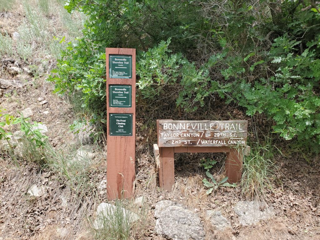
Now the bad news. Even with all of those caveats, there is a lot of land with real potential for development that I do not want to lose, including much of the existing and proposed Bonneville Shoreline Trail. The “Urban-Wildland Interface” is a crucial area for our quality of life, because it gives us beautiful natural spaces close to our homes. A couple of notable examples visible on this map are the foothills above Provo, Pleasant Grove, and Bountiful, where (ironically) millions of federal and state dollars have been spent to acquire private property and transfer it to the National Forest, and build trails. If you have driven past Bountiful and seen the houses extending far up the slope, imagine them going right to the top of the ridge. This leads to a second problem: although the text makes a nod to affordable housing, the lack of which is a crisis in states like Utah, Nevada, and Arizona, these lands are often in the wooded foothills overlooking our cities, so they are much more likely to be developed as multi-million dollar mansions. I know of a few developers who have had exactly this in mind for many years, and I would not be surprised if they were the ones bending the ears of our legislators. Oh, if you look closely at the map, there is a decent chance that the biggest winners of this might just be the ski resorts…
Lastly, I think that there is actually danger in the good news. As I said, IF reasonable bureaucrats faithfully interpret the text as our legislators are claiming they should, I seriously do not think they will be able to sell off the minimum requirement of 0.5% of BLM and USFS land. I have little faith that the current political appointees at the Departments of Interior (BLM) and Agriculture (USFS) will be reasonable or faithful enough to just say “it can’t be done.” I am thus very worried that they will find loopholes in the text that allow them to sell off lands that have very little to do with the spirit of the law (that is, land not included on this map). Here’s a nightmare scenario: a billionaire pays a rancher to leave, deactivates his lease, then convinces the USFS that the land is adjacent to a “population center” (i.e., another guy’s cabin), and suddenly hundreds of acres in the Wasatch mountains (including existing trails) are fenced off around a single lodge (i.e., “housing”) and a private hunting club, as is so common in the mountains of the East (and surprisingly common around here). Is that likely to happen? Probably not, but if someone figures out some kind of workaround like this, it could be repeated again and again. Then again, given the nature of this administration, there is a decent chance that they could abandon any pretense and just sell off whatever anyone asks for and dare opponents to take them to court (okay, I’ll cut off my political rant here).
Does Utah (and other western states) need more affordable housing? Desperately. But I don’t think federal land is the primary problem. Frankly, I don’t know what the solution is; developers seem to have decided that condos and townhouses are the only affordable solution, but Senator Lee has said he wouldn’t allow high density in these sold lands. Most of these growing cities still have a lot of undeveloped private land, especially in agriculture that uses more water per acre than residential subdivisions, and is flat, next to roads/utilities, and cheaper to develop.
If this bill must go through, I would hope at a minimum that it includes a few changes: 1) remove the minimum total to be sold, I cannot think of a non-nefarious reason for including it; 2) include the buffer distances, but limit what counts as a “population center” to existing urban development; 3) include more specifics on what counts as “adequate for housing,” including criteria that could be used in a GIS analysis like mine; and 4) allow for public comment, like every other public land law (which I’m sure Lee is specifically trying to omit). If the result is that a few thousand acres of isolated, unused parcels across the West are privatized, I can live with that. But I do not think that is the real intent or likely outcome of this current effort; there appear to be much greater plans and greater dangers, and that’s why I’m opposed to it.