June 11 2022: 3.3 miles, 1.5 miles unofficial BST. Trailforks log
Today’s hike was around Bell’s Canyon Reservoir in Sandy, one of my top two or three “backyard” trails along the entire Wasatch Front. Even though there is no sign of this currently, this trail is planned to become part of the Bonneville Shoreline Trail, but challenging gaps to the east and south mean that it may take a while. The brand new (and not quite finished) Preservation Trailhead is a great addition, with a big parking lot that represents a significant investment by Sandy City to keep up with the astronomical increase in outdoor recreation. And yet, on a very hot June day, this and the other two trailhead lots were full and overflowing.
This area is unique from the rest of the Wasatch Mountains, a lot more like Switzerland than Utah, so this was a great place to talk about science rather than trails policy. Our guest today was Dr. Ron Harris, a geology professor at BYU. Dr. Harris and I had a great conversation about the unique geology here:
The huge granite intrusion (30 million years ago) that makes the canyons and Lone Peak white, and was used to build the Salt Lake Temple. This intrusion also formed the rich ore veins of Alta and Bingham Canyon.
The Ice Age glaciers (100,000-15,000 years ago) that came further down here than anywhere else, leaving the massive moraines of giant boulders that form the bowl in which the lake sits. In fact, the Little Cottonwood Glacier likely extended well into Lake Bonneville at its height.
The Wasatch Fault (20 million years ago to present), with its 30 meter-high exposed scarp here created by major earthquakes as little as 1,000 years ago (yes, that means we’re due).
Even though it was relatively short, this was a great hike on a great trail that should make for a great episode!
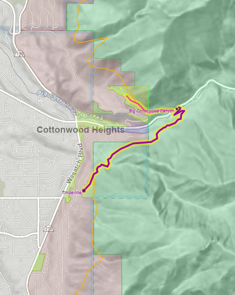
June 4 2022: 6.1 miles, 1.6 miles official BST, 0.5 miles unofficial. Trailforks log
Today’s outing was much shorter than usual, but very productive. We hiked a brand new section of BST from Ferguson Canyon into Big Cottonwood Canyon; in fact, it isn’t quite done yet, but should be completed this year. By design, the Forest Service has completed the middle, which is very visible from the valley, but has not built the two ends yet, so it can be difficult to find. Probably best for us to leave it alone for a bit. It’s a well built trail though, with wooded sections and a cut across an exposed steep slope that was likely quite difficult to build by hand. Fortunately, the Forest Service has had help on this section from the Cottonwood Canyons Foundation, which has a professional non-profit trail construction crew that does great work.
Our guest today actually got his start on that crew. Patrick Morrison is a project specialist at the Utah Office of Outdoor Recreation, a state department that supports trails and other outdoor activities across the state. This office does not manage trails directly, but provides support (including education, coordination, and funding) to cities, counties, and non-profit groups who build and manage trails. This year, thanks to the state legislature, their Outdoor Recreation Grant program funded $11 million for recreation infrastructure, including at least $2 million for projects related to the Bonneville Shoreline Trail. Thanks!
Patrick and I had a great conversation about the support our state government provides for the outdoors, and why it is so important. The state recognizes both the profound economic impact that recreation has statewide, and the need for wise stewardship of this resource. In fact, Utah had the first office in the country dedicated to outdoor recreation. In July, their role will be expanding as they move to the Department of Natural Resources to become the Division of Outdoor Recreation.
After we left Patrick, we explored an unofficial trail (one of the few stretches of unofficial BST candidate trail in Salt Lake County) on the north side of Big Cottonwood Canyon. This is just a half mile dead end, so not yet worth designating, but it is probably the best general route for a future BST leading toward the current Mt. Olympus segment. On the plus side, it is all on public land (USFS and Salt Lake County). However, the current trail is rather steep, and varies from a nice, well-worn trail to an overgrown deer track that is hard to follow. The best part is at the top, where it follows the route of a historic pipeline that brought water to the valley. A few remnants of the wooden pipeline still exist (so leave them there!).
Today we’re back in order, picking up the trail in the Corner Canyon area where we finished Episode 10. This area has the largest city-owned trail network in the state, including at least 10 miles of BST, so it was a great place to learn more about what cities have done and can do to improve our trails with Greg Hilbig, the manager for Draper City Trails and Open Space. Greg has worked tirelessly to build over 150 miles of trail across the Traverse Mountain in Draper, and has also helped other cities (adjacent to Draper and around the state) conserve and develop their foothills open space.
Over the past 20 years, Draper has acquired over 5,000 acres of land on Traverse Mountain, both to conserve the land and water (Corner Canyon is one of the major sources of Draper’s drinking water) and to provide recreation opportunities through its trail system. When combined with neighboring Alpine and Lehi, there are about 11 square miles of city-preserved land, which would be one of the ten largest city parks in the United States if it were designated as an official park or preserve. A truly impressive effort!
Greg was very informative explaining how Draper has invested in building the Corner Canyon trail system and has continued to invest in maintaining it as it has become very popular, famous, and crowded. A highlight of that commitment is the Bear Canyon Bridge (2015), possibly the most impressive trail structure on the entire length of the BST (yes the I-80 bridge is bigger and more expensive, but not as downright cool). Fortunately, they were able to build an impressive sponsorship team, including a local contractor, that was able to build it at a reasonable cost. This allows us to get a great view of this beautiful perennial stream, while preserving it as a valuable culinary water source.
In addition to the bridge, this segment of the BST has several highlights, including crossing several small streams, ending with the Rocky Mouth Waterfall in Sandy, which is in my opinion, the most unique waterfall along the Wasatch Front (it has a very southern Utah feel). To reach it, we traversed the short section of the BST recently built by Sandy City, an impressive task considering that it is in the extreme corner of the city and they are still a ways off from being able to built the entire length of the trail in the city. So for now, we will spend the next few episodes bouncing to several isolated segments in Salt Lake County.
May 21, 2022: 5.1 miles, 3.8 miles official BST. Trailforks log
Yes, this is not an error, we are jumping ahead. We have some great guests lined up on some segments of the BST that they know very well, but to work around their schedules, we will be filming much of the Salt Lake Valley out of order. The episodes should still come out in order, if a bit delayed.
Today we traversed the face of Mt. Olympus, an area with a few very popular trails (judging by the multitude of cars overflowing the trailhead parking lots). We were joined by the person who has probably put more effort into this stretch of the BST than anyone else (who is still with us), John Knoblock. John is currently the chair of the Bonneville Shoreline Trail Committee, the citizen organization that has been primarily responsible for encouraging the construction of the trail since its inception in the early 90s, especially in Salt Lake County. He first got involved in the BSTC around 2010 as this section was first being built in his own backyard, and moved into a leadership role as the original leaders retired. In addition to running the BST website, John has been personally instrumental in getting several recent additions to the trail done in the valley, and continues to do the often challenging work of forming long-term relationships with land owners and coordinating the multiple jurisdictions and user communities necessary to extend the trail piece by piece.
Our hike started up Heughs Canyon, which looked a little uncertain with no real trailhead, having to pass through a gated community and up a driveway to reach the trail. John verified that the trail has full legal access here through easements put in place by forward-looking planners. Heughs Canyon is a steep trail, but a beautiful walk along a perennial creek, which has been significantly improved in recent years to handle increased traffic.
The southern segment of the BST here was completed in 2019 with incredible effort of the Forest Service, the BST, and local citizens. Watch for the plaque honoring Brett Alan Smith, one of the original champions of the BST; this segment was his personal crowning achievement, completed just weeks before his death. Much of it passes through the Mt. Olympus Wilderness, so it had to built by hand through very rugged terrain, including several sections of solid rock. The views were incredible, though! Due to the wilderness, mountain bikes are not currently allowed here (the trail is currently too rough to be very enjoyable anyway), but the Bonneville Shoreline Trail Advancement Act (H.R. 2551, S. 1222) aims to solve this issue by adjusting several wilderness boundaries to move this and other BST segments from wilderness to normal National Forest administration, in which multiple types of users are allowed. The bill compensates by adding an equal amount of land to another part of the Mt. Olympus Wilderness. As of this writing, both bills were recently reported favorably out of committee, so they may actually pass this year!
Continuing the trail south of Heughs Canyon to Big Cottonwood Canyon will be a challenge, as the route is almost entirely on private land. The main impediment is a large gravel pit, but at some point in the future, operations there will be completed, and the owners will likely want to develop the land, which would probably require a trail route.
The northern half of the trail connects the Mt. Olympus summit trail to the Olympus Cove neighborhood, which was completed in about 2013 after three years of construction by volunteers and forest trail crews. This is a very nice trail through the woods on the north-facing slopes of the mountain. Fortunately, Salt Lake County was able to secure access into the neighborhood, but continuing the trail from here to Neff’s Canyon and on to Millcreek Canyon has proven to be an insurmountable challenge so far, due to private land owners and some extremely challenging terrain. This could be one of the last sections of the BST to be completed.
May 14 2022, 7.5 miles, 6.5 miles official BST. Trailforks Hike Log
Today we officially started our sojourn in Salt Lake County at the Point of the Mountain, hiking across the southern benches of Draper to Corner Canyon. Draper is one of very few cities along the Wasatch Front that has completed the entire Bonneville Shoreline Trail through its jurisdiction (at least in a “version 2” constructed singletrack form), and they have done a great job here.
This was one of the nicest sections of trail we’ve hiked yet. In the 20 years since it was built (around the same time that the South Mountain area was developed), the vegetation has reclaimed the cut slopes, so it looks very natural. As one of the few segments on a north facing slope, it is mostly wooded, so you feel like you’re in nature, even though for much of the time, you’re basically in someone’s back yard. The only drawback we could find is that it had to make a couple significant climbs to weave its way around subdivisions and cross under Traverse Ridge Road. That said, there are other segments with more hills.
Along the way, we got a good view of the soon-to-be-demolished state penitentiary, the scars from the old Widowmaker motorcycle hill climbs, and the Draper LDS Temple, where we finished. All in all, a great day, and a highly recommended segment of the BST.
April 30 2022, 7.5 miles, all official(ish) BST. Hike Log in Trailforks.
At the end of Season 1 (Episode 7), we started the beginning of the Sensei Trail, but decided to call Utah County done and skip ahead to Draper. I knew that a connecting trail had been completed in 2021 over the ridge, but only found out after filming that Lehi and Draper are considering designating it as a temporary official BST connection, so we decided to give it a try.
Lehi City has been proactive in acquiring the unbuildable highlands of the Traverse Mountains from developers, creating (along with Draper City) a permanently conserved area of at least 7 square miles. Working with the Traverse Mountain Trails Association (TMTA), the city is building an impressive trails network in the foothills here. While the process has been largely driven by the mountain biking community, and the trail design shows that emphasis, these trails are also popular with hikers and trail runners. A combination of the Sensei Trail (completed in 2018), Mo-mentum (2020), Tráverse Travérse (2021), and Ann’s Trail can be used to connect Lehi to Draper, with its extensive trails network including the BST (which we’ll explore in Episode 10).
Since we had already hiked part of Sensei last year, we cheated a bit and started in the middle, at the top of Fox Canyon Road. A new phase of the Hidden Canyon/Canyon Point development is actively being built up the canyon, so this access is officially closed to the public. However, they are in the final phases of the project, butting up against public property, and the approved plan includes a trailhead about where Sensei Trail crosses the old road.
Unlike a lot of the older trails above the Wasatch Front, these trails are being designed and built very carefully, with an emphasis on having very gentle grades despite the rugged terrain. The advantage of this is that we climbed more than 600ft to the summit and hardly ever noticed we were going uphill. The disadvantage is that the trails have to go around every little ravine and ridge, creating an extremely circuitous route. We could have taken less than a mile following an old (very steep) trail straight up the canyon to the summit, and instead it took us 4.5 miles (including a shortcut that saved an additional mile). Perhaps future trails in the network will provide a more efficient route to the top with a balance of grade and distance (please?).
The Draper side of the traverse is a much greater elevation gain (1,000ft to the Oak Hollow Trailhead, the nearest access), and generally steeper, so I’m glad we were going down it. The climb is mitigated somewhat by being on the north slope with lots of shady oak, and a multitude of switchbacks (at least 20) to temper the grade. We encountered a lot more traffic on this side, especially mountain bikes.
So what is the “state of this BST?” For having to climb over this ridge, this was actually an enjoyable hike. Maybe it was just the great weather, but it did not seem at all difficult, and the views of both valleys, as well as Lone Peak, were awesome. I would fully support this being a connecting route for the Bonneville Shoreline Trail for the time being.
Rocky Ridge, Mona, 6 miles, 3.5 miles unofficial trail
It is great to back in the swing of State of the BST again! We look forward to a great season on the trail. Our goal is to complete Salt Lake and Davis Counties this year, saving the northern end for Season 3. This year we are going to try releasing shorter episodes (10 minutes) more regularly (about every 2 weeks). We’ll see how it goes.
For our first outing, we decided to make a detour and go back to where we started, at the south end of Santaquin, and explore the possibility of the Bonneville Shoreline Trail continuing south toward Nephi. There is not a continuous trail extending through Juab County, but there are some short stretches, mostly ATV doubletrack, that could be used. We tried out two short segments today, both of which are part of the state-owned Santaquin Wildlife Management Area.
First we hiked south from Santaquin on a track that crosses into Juab County. The WMA has designated it as an open ORV route (except in winter when the big game are there), but it doesn’t have an official name; I put it into Trailforks as the Santaquin Pass Trail. It is an enjoyable gradual climb and drop, with some great views of Juab Valley and Rocky Ridge, the small town built by the Apostolic United Brethren group.
For our second segment, we followed a faint double track from Mona Pole Canyon (a rough road that connects up to the Nebo Loop Road) that follows the base of Bald Mountain to North Creek. It wasn’t a great BST candidate trail, too much up and down, but North Creek is a beautiful canyon that we never notice as we drive by on I-15 focused on the traffic. The trail up the canyon is not maintained, but the Creek and the cliffs were incredible.
Will the BST ever be built through Juab County? Here are a few factors: 1) unlike most of the rest of the route along the Wasatch Front, this is a rural area without lots of urban neighbors wanting recreation in their backyard. 2) Nephi City is thinking about building a stretch around town, but there isn’t any usable trail there yet. 3) Most of the upper parts of the foothills are either WMA or National Forest land, and it is usually easier to get permanent trails on public land. 4) On the flipside much of the land between there and I-15 is private, which limits access to the foothills. Personally, I don’t expect to see this trail completed in the foreseeable future; we have a lot of more pressing needs.
September 4: 7 miles total, 0 miles official BST, 5.5 miles unofficial route
Spencer and I had a great hike along the base of the Traverse Mountains to wrap up our filming of Episode 7. And Utah County. And Season 1 of the State of the BST. We need to take a break for the fall so Spencer can focus on paying jobs, including teaching a filmmaking class at UVU (yes, this professor dad is very proud of him). Originally, we had planned to skip most of this area because Lehi, Draper, and Highland have plans for the BST here, and there is no way to follow their intended route. However, for the sake of having a nice ending, we decided to cross the general area however we could. Fortunately, there are several old 4×4 roads crossing the south face, so we set out from the Hog Hollow Trailhead in Highland and headed West. It turns out Highland has very little involvement with BST planning, as this trailhead is at the extreme northern edge of the city, 50 feet from the Draper city limits. But we do appreciate the trailhead at least.
Jeep roads seem to have been created with little regard for grade, and we spent a lot of today going up hills and down into ravines. Clearly, this was not a good route for a permanent BST, but it is in the general vicinity for the planned route, and it was a lot shorter than a more level route that would have to zig zag a lot more around the topography. For example, the Fango trail just uphill, which could actually become part of the BST, covers the same breadth of the hill as we did with twice the length.
Much of today’s hike and discussion revolved around the Micron memory chip plant, which was visible below us most of the time. It is amazing to remember when they built this plant in the early 2000s, people thought they were crazy to build a high tech facility up on this barren hillside, so far from all the tech companies in Provo and Orem. They were able to buy 1,000 acres of “practically worthless” land for a steal. And we all thought the “little town” of Lehi was nuts for giving them a huge tax break, with the pie-in-the-sky idea that they might attract other tech businesses to the Point of the Mountain. Boy, were we wrong! Lehi has more than doubled in size in 20 years to become Utah County’s third largest city with the boom of the Silicon Slopes area. This year, Micron sold most of their undeveloped property to developer D.R. Horton; I’ll bet they made more profit with that sale than with chips this year. D.R. Horton has big plans for developing this hillside. Although there is a lot of debate in the community on the details, it looks like they will be preserving a fair amount of open space, especially in the upper reaches where the BST will pass through. Lehi and Draper have a good track record of reserving large blocks of open space on this mountain while allowing pockets of development.
As we walked through the upper part of the Micron property, I was amazed at the beauty and solitude of oak woodlands and meadows, despite the houses and businesses visible above and below us in the distance. We did not encounter a single other person the entire time. I hope the inevitable future development will retain significant areas like this.
Eventually we returned to civilization in the Traverse Mountain neighborhood. Here the Traverse Mountain Trails Association (TMTA) is actively working with Lehi City to build a multi-use trails network, and they already have an exemplary track record. Their first project, the Sensei Trail, is a well-designed, well-built, well-maintained trail that is as enjoyable to hike or run as it is to bike. Much of it could easily become part of the BST, depending on how Lehi, Draper, and Geneva Rock figure out how to get the trail around or over the Point of the Mountain. We followed it for a little while, but another 5 miles would have been too much today, and this episode is already chock-full of footage.
August 21: 4.3 miles total, 0 miles official BST, 3.9 miles unofficial route
This was a very interesting segment, the first in a long time that I have not hiked before (at least, a lot of it). This segment goes in and out of private property and the National Forest, actually the Lone Peak Wilderness. In 2017, Alpine City proactively secured public trail easements across the private segments, which makes them ready to be designated as the BST. However, the wilderness sections are more difficult, because the BST is intended to be open to all non-motorized traffic, but mountain bikes are not allowed in wilderness areas (despite the fact that 75% of the traffic on this trail is on bikes). Yes, fixing that takes an act of Congress; for the last two years, Senator Romney and Congressman Curtis have introduced bills (currently S.1222/H.R.2551) that would adjust the boundary of three wilderness areas along the BST (here, Mt. Olympus in Salt Lake, and Mt. Naomi near Logan) to exclude the BST, a total of 250 acres that would compensated by adding 250 acres up Mill Creek Canyon to Mt. Olympus Wilderness. Seems like a good solution to me, especially since the area we hiked through has lost any wilderness character as houses have been built right up against it. However, it is hard to get much done in Congress these days, both seem to be lost in committee, although the Senate bill has a chance of being rolled up into another omnibus public lands bill, which tend to have a better chance of passing.
Along our hike, we had a fun visit with one my best trail friends (and a former student), Brandon Stocksdale, who has a great job that most people wouldn’t imagine even exists. He’s a community planner with the Rivers, Trails, and Conservation Assistance Program (RTCA) of the National Park Service. Yes, the Park Service, and no, he is not associated with a national park. Brandon and his colleagues basically act as consultants for cities, counties, and trail associations to help them plan and conserve open spaces and outdoor recreation opportunities. He is especially good at going into an area and getting all the stakeholders (cities, counties, state, federal, private landowners, citizens) around the table to have productive discussions about how best to manage urban open space. That’s how he helped to create the Utah Valley Trails Alliance (UVTA), of which I am currently the chair (and desperately trying to keep a little of his momentum).
We had a great chat about the great outdoor opportunities we have along the Wasatch Front and the challenges of making them available to everyone, the joys of cat herding (i.e., running stakeholder groups), and the prospects of getting the BST through Alpine, which he has worked on extensively.
We finished our trip by following some mountain biking trails through Lambert Park, one of the first dedicated Mountain Biking trail parks in the state, built about 20 years ago and managed (quite well, if I may say) by Alpine City. How the BST would pass through here I’m not sure, but it was a nice path we took.
August 10 2021: 7 miles total, 6.3 miles official trail, 0.7 miles unofficial route
As the fires rage on the west coast, the Wasatch Front is full of smoke. We delayed this hike a few days trying to wait it out, but decided to go today when the air quality was slightly better than the weekend. Episode 7 is going to cover a lot of territory to finish off Utah County; today’s route traversed the base of Mahogany Mountain.
The first few miles, from Grove Creek Trailhead to the Cedar Hills city limit, is one of the newest segments of the Bonneville Shoreline Trail (at least it’s the newest in Utah County). The Utah Valley Trails Alliance worked with Uinta-Wasatch-Cache National Forest in 2019 to develop an official trail network in the Pleasant Grove area, designating about 20 new miles of trail. That said, all of the “new” trails were actually existing social trails that were legalized, including this 2.5 miles of BST. We like this route, which gets up in the hills a bit for some great views and more solitude then the “Bench Road” below along the Salt Lake Aqueduct pipeline, it does have some sections that are too steep and need some rerouting.
Eventually, however, the alternative routes end, so through southern Cedar Hills, the trail follows the pipeline utility road. This pipeline, which is mostly underground but occasionally exposed where it crosses a draw, has carried a significant part of the Provo River to the Salt Lake Valley since 1951. The road here is nice and level, if somewhat dull. Perhaps when “Phase I” of the BST is completely connected, a new route could be developed here further up in the hills.
The last mile is a paved pathway, part of the extensive paved trail system built by Cedar Hills (thanks to development fees from its large developers in the early 2000s). We took this opportunity to experiment with filming by bicycle. It was a good change of pace!