

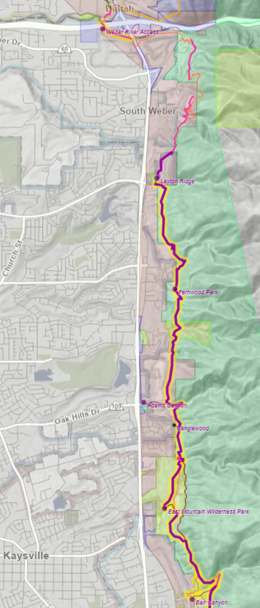
11 March 2023: 8.5 miles, 6.8 miles official BST, 0.4 miles unofficial BST. Trailforks hike log.
We can’t seem to get rid of this winter! With the recent mix of sun, rain, and snow, we weren’t sure what the state of the BST up north would be. I have a firm rule about not hiking muddy trails. But the forecast for today was sunny and 42°, so Spencer and I couldn’t pass up a chance to finish Davis County before “mud season” kicks in. Turns out we chose wisely! Almost the entire trail was still snow-covered, packed solid by the frequent users, which made for a great trip, although walking on packed snow is just enough harder than a dry trail to make us quite tired by the end.
We started across Bair Canyon from where we ended the last trip above Fruit Heights, verifying the difficulty of connecting the gap. We hope the city can find someone to work with them on this. The trail north of the canyon appears to be an old rock quarrying road. We tried the trail above the Kaysville gun range, but it turned out that it was open and a lot of people were enjoying the sunny Saturday there, so we dropped down a not-really-a-trail to the East Mountain Wilderness Park to rejoin the official trail.
The BST route through the park is not signed but we think we followed the most likely route. At the top, where the trail crosses Holmes Creek, Kaysville installed a new bridge in 2020, which they had to bring in by helicopter. The new route of the trail here is much nicer than the old crossing. The rest of the trail north of here is a long-established trail built by Layton and the Forest Service in the early 2000s, and improved in many sections during the early 2010s. The next major crossing was Adams Canyon, which had a beautiful conifer grove that is rare at this elevation. This part of the BST had many more people than anywhere else we’ve been in Davis County; the waterfall up the canyon is a popular destination. The new trailhead that was recently built at the bottom of Adams Canyon as part of the US-89 reconstruction was apparently very needed.

Between Adams Canyon and Fernwood Picnic Area, the trail is nice and level, with some small creek crossings. The only downside is a massive gravel pit. North of Fernwood, the trail does not appear to have had as much traffic; the snow is deeper and the trail was not packed quite as well; “postholes” (deep footprints) were so common that it was difficult to keep our balance. The long bridge (possibly only second longest to Draper’s Bear Creek along the BST?) installed in 2014 across the Middle Fork of Kays Creek was a highlight here.
The main drawback of this entire hike, as in many places we have been over the last couple years, was the lack of signage. Over 7 miles, we probably saw 4 BST trail markers. There were a lot of junctions where it was not at all clear where the trail was supposed to go; ideally, I would have at least 20 markers along this section. I think I will push for signage as a fundraising priority. They’re a lot cheaper than trying to buy large parcels.
North of Layton Ridge, there is a short dead end trail built by the neighborhood developers, but beyond it is private property. The snow wasn’t groomed, and we were too tired to hike through two feet of snow, so we’ll save that for another day. Instead, we went north to the Weber River, to see the plans for crossing this congested canyon mouth. I-84, the railroad, the river, the gravel pits, and private property in the foothills have conspired to make this canyon more difficult to cross than any other. The compromise is to bring the trail down into the valley to join a future extension of the Weber River Parkway. UDOT is currently building a pedestrian underpass under US-89 for the trail, and a decent trail already exists along the south bank until the river goes under I-84. After that, a bridge over the river will need to be built, but we’ll talk more about that next time.