Category: Trip Reports

Payson: Potential and Obstacles

6 miles (0 miles official BST, 5 miles unofficial route)

Today’s trek looped around the edge of Payson, with several very nice trail sections that have good potential for becoming the Bonneville Shoreline Trail, but there are a few access issues that may keep the status quo without funding or other changes.

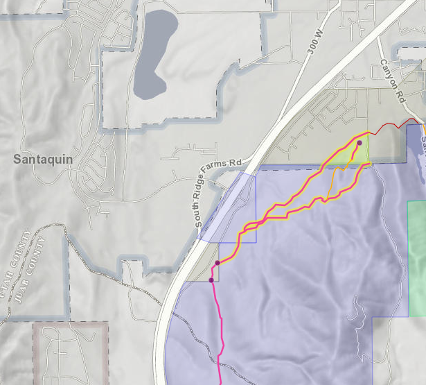
Starting at Picayune Canyon, we climbed onto a very narrow band of the Bonneville bench within the National Forest (although we hardly saw a tree all day). The trail on the bench is very nice, if a bit faint, but both of the two trails climbing up are unsustainable steep; we would probably need some switchbacks here. Three ravines along the way had poor crossings, but between them the views of Spring Lake and southern Payson (including the LDS Temple) were spectacular.

North of the third ravine, the route crossed into private property. This area has been generally closed to the public, but the new landowner is potentially interested in trails and open space, and we were able to get permission to explore. The best route for the BST through here follows the road along a natural gas pipeline, nice and level. As it wrapped around the north end of Dry Mountain, we finally were in some trees, a very nice trail. We hit a narrow band of Forest Service land before a private property fence stopped our progress. This narrow band crosses Payson Canyon, so we decided to do a bit of bushwhacking to see if we could cross on public land. The short answer was “yes,” the long answer was “hardly.” We had to drop 200ft down an extremely steep slope, then we had to cross Canyon Road, then Peteetneet Creek (building our own temporary crossing with a log). So yeah, we could get a public land trail through here, but it would be challenging and expensive.

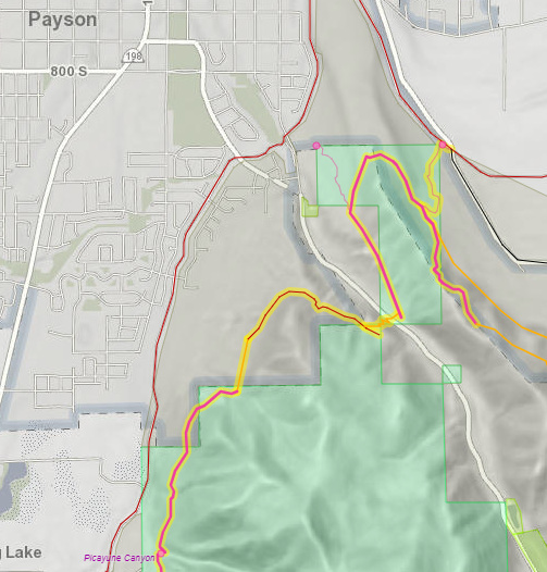
Now on the flanks of Tithing Mountain, we climbed another gas line utility road up to P Hill. These utility lines often look like promising trail routes because they are nice and straight, but that often means they go straight up and down steep hills; this stretch would need rerouting in places to be usable. P Hill is an “island” of public (Forest Service) land, which should make trail designation possible, except that all four of the current trails that enter it pass through a small stretch of private property: in some cases, no more than 100ft. Only one of the four (in the northwest corner, just off Canyon Road) currently appears to be unrestricted. The one in the northeast corner, on Goosenest Road, just about touches the road, except that you have to cross the Highline Canal, which is not safe. Fortunately, as we ended our hike today, it was still dry.

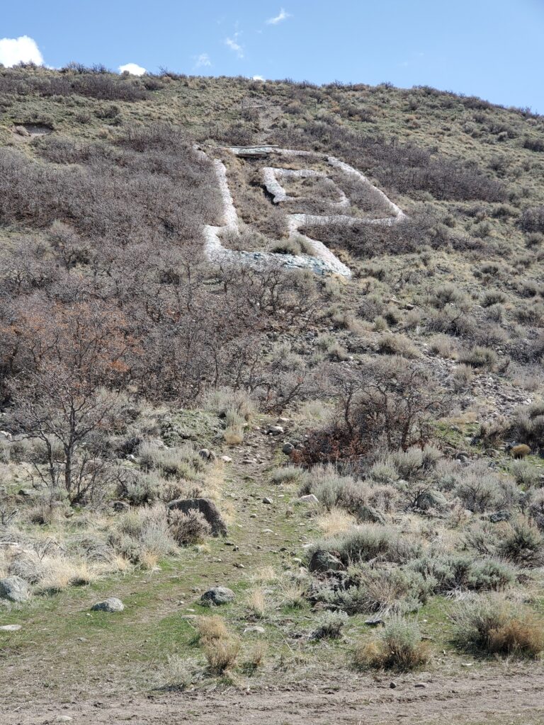
Passing the base of the P brought to mind the history of these “geoglyphs,” and my obsession many years ago with attempting to “geo-collect” all of the hillside letters in the Western U.S. I eventually mapped over 500 of them. We’ll see several more close up along our journey.

From the east side of P Hill, the future route of the BST through Elk Ridge, Woodland Hills, and Salem is much less clear, with three options:

  • Most city and county plans have it as a paved bike path along the Strawberry Highline Canal, much like the Murdock Canal trail in the northern part of the County. This will be a great trail, and worth doing eventually, but it will be insanely expensive and is not really the character of the BST. Currently, a gravel road follows along the canal, but it is clearly posted no trespassing at every road crossing.
  • The second option is to keep the wildland-urban interface character of the trail by wrapping around the upper reaches of Elk Ridge and Woodland Hills, at the base of the steep mountains. This will be a beautiful route, but it is a very long stretch of new construction, and almost all of the route passes through private property, including several who have actively restricted public access. Also, this would require a significant climb above the actual shoreline, with the upper edges of Woodland Hills being above 6,000ft. Future suburban development in those hills may make some of this trail possible.
  • The third option would be to just walk through the neighborhoods of lower Elk Ridge and upper Salem. This route most closely follows the Bonneville Shoreline elevation (5,100ft), but sidewalks don’t quite seem BST-y

Unfortunately, none of these three options is currently traversable, so we have no alternative but to skip the next several miles and start again in Spanish Fork.

Santaquin: Life on the Edge

Today we started the “real” episodes of State of the BST! March in Utah being March in Utah, after our nice spring weather three weeks ago, we started today hiking in several inches of snow. Half of it had melted by the time we finished.

2002 Mudslide, photo from US Forest Service

We had to skip a couple miles from our last jaunt because of private property concerns. One of the rules we are living by is to only hike sections where we would be willing to let all of you visit, which means no trespassing on posted private property. So, we started this morning in the southeastern corner of Santaquin, along the big diversion channel built after the mudslides of 2002, which were a result of the “Mollie” forest fire on Dry Mountain in 2001. So it seemed a great place to talk about the nexus of natural hazards we seem to have along the BST (the Wildland-Urban Interface or “WUI”), and I know the perfect guest to talk about hazards, my office neighbor, Dr. Matt Bekker.

Matt is a physical geographer who specializes in dendrochronology (tree rings), but he also teaches a general education course called “Landscapes of Disaster.” We had a very interesting congregation about the recurrence of fire, floods, debris flows (mudslides), landslides, and earthquakes along the Lake Bonneville benches, the irresistible pull of the views, the woods, and the wildlife that draws new housing developments up into these areas (including what looks like another subdivision preparing to be built), and how we are (or should be) trying to mitigate the hazard that results from this collision along the line that is the Bonneville Shoreline Trail.

Our hike is highlighted in yellow.

The Trail, you say? Well, we got a mixed bag. On the east side of town, there is an ATV track between the edge of the subdivisions and the base of the mountain that can (at least for now) suffice as a BST. Some of it is on city-owned property, but most is on private property, so who knows if and when it will be developed. Also it is a steep climb from the northeastern corner of development at East Side Park (just below the actual Bonneville shoreline at 5000ft) up to the southwestern corner of town at the end of Oak Summit Drive at 5300ft. So we went looking at a route further up in the hills where development will likely never occur; even though it is far above the shoreline, more of it is on public lands and it could be taken in a more level route all the way around the city. I had hiked this route before and remembered a pretty good trail, but today, even though we were following it exactly on the State of the BST Explorer map, it was all bushwhacking along a deer path. At least the views were great, and it seemed a good route for future development. It crossed some very large geotechnical trench scars, so it looks like someone is planning a development right up against the mountain (P.S.: I found out later, it is called Scenic Ridge Estates, and apparently they were trying to find the Wasatch Fault to buffer the houses away from it. See, a perfect place to talk about natural hazards!) Looking at the 2016 Santaquin Parks and Trails Plan, it looks like the intended route of the BST might climb from Peter Rabbit Spring (270 South Oak Summit Dr) up to the higher bench.

After a gap of several miles to avoid the gravel pit north of Santaquin, we started at the Picayune Canyon Trailhead (National Forest) and went south for 1.6 miles and back overlooking Spring Lake. The northern end, in National Forest Land, was a very nice (if unofficial) trail built by local horseback riders that could instantly be designated as BST. The next half mile, on private (but not posted) property, was a stretch of very roughly plowed firebreak from the 2018 Bald Mountain Fire (a good precaution even though the fire never actually came down this side of Dry Mountain). It was clear of trees and not too steep, and used a lot by horseback riders, but it would need some work to be a decent trail. The southern half mile was along a narrow doubletrack just outside a tall fence surrounding a large orchard. I believe this fence was put in after the 2018 firebreak was cut through here, even though the same person owns the property on both sides of the fence. Does this mean he is allowing public access on the mountain side? This trail has a lot of steep up and down along the fence, so we tried to find an alternative trail in the hills, but this turned into another bushwhack. So, tonight I’m editing the map to take out a few trail segments that I had thought were in better shape, but I’m also adding a few that we found. I guess the trip accomplished its purpose.

Santaquin: The First “Mile”

Santaquin, March 9, 2021

I am so excited to explore the BST and evaluate how much has been accomplished in 30 years! Spencer and I started this 200 mile expedition at the Utah-Juab County Line. It turns out we could have started a couple miles further south, but that would have mostly been a hill climb, and this was a good place to introduce the project.

Hidden just beside I-15 in the southern end of Santaquin is a stretch of the original US-91 highway, replaced by the freeway in the early 1960s. Technically, it is a road, but the pavement is in such bad shape, it may as well be a trail. Here we worked on getting our filming legs under us. I am clearly no actor, but we wanted this intro to be completely scripted, so it took us a lot of takes to get it right. Spencer was also trying out some different creative approaches; I like what he chose in the end, except for my lame pointing.

We entered the Santaquin State Wildlife Management Area on a dirt road. This is not officially part of the Bonneville Shoreline Trail; in fact, we won’t reach the first official stretch until Springville. It was just an ordinary rather level dirt road, lots of time to do a few takes.

Eventually we shifted over to the bank of a rather large canal. I believe this was built in the 1940s to take excess water from Summit Creek over to the reservoir on the other side of the valley. It doesn’t appear to have been used for irrigation in this area, and looks like it was abandoned a long time ago. At times, there was a decent trail along one bank or the other. The north bank had great views of Utah Valley, as well as the rapidly expanding city of Santaquin.

Eventually we left the WMA, crossing into the Theodore Ahlin Park, site of Santaquin’s urban fishing pond. As these ponds go, this one is very well done, with a wide path surrounding it, and a disc golf course.

I don’t know if I will be posting my exact route every time. Although none of this trail was official BST, it was all on public land that is open to travel, so here is my route on Trailforks. Yes, our “first mile” was 2.25 miles; a fair bit of backtracking for multiple takes.

css.php